Geospatial - Flutter SDK
On this page
New in version 1.6.0.
Geospatial data, or "geodata", specifies points and geometric objects on the Earth's surface. With the geodata types, you can create queries that check whether a given point is contained within a shape. For example, you can find all coffee shops within 15 km of a specified point.
Flutter SDK v1.6.1 and later adds support for geospatial data in Atlas Device Sync. This allows you to subscribe to geospatial queries in a synced database. If you try to subscribe to a geospatial query with an older version of the SDK, you will receive a server error with a compensating write. For more information about managing your Sync subscriptions, refer to Manage Sync Subscriptions - Flutter SDK.
For more information on querying geospatial data with Device Sync, refer to Geospatial Data in the App Services documentation.
Geospatial Data Types
The Flutter SDK supports geospatial queries using the following data types:
GeoPointGeoCircleGeoBox
The SDK provides these geospatial data types to simplify querying geospatial data. You cannot persist these data types directly.
For information on how to persist geospatial data, refer to the Persist Geospatial Data section on this page.
GeoPoint
A GeoPoint defines a specific
location on the Earth's surface. All of the geospatial data types use
GeoPoints to define their location.
A GeoPoint is an object with two required properties:
lat: a double valuelon: a double value
A GeoPoint is used only as a building block of the other shapes: GeoCircle and GeoBox. These shapes, and the GeoPoint type, are used in queries, not for persistance.
To save geospatial data to the database, refer to Persist Geospatial Data.
GeoCircle
A GeoCircle defines a circle on
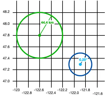
the Earth's surface. You define a GeoCircle by providing:
A
GeoPointfor the center of the circleA
GeoDistancefor the distance (radius) of the circle
The radius distance uses radians as the unit of measure, implemented as
a double in the SDK. The SDK provides convenience methods to create a
GeoDistance from other units of measure:
The following code shows two examples of creating a circle:
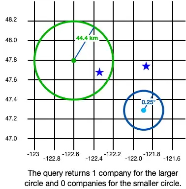
final smallCircle = GeoCircle(GeoPoint(lon: -121.9, lat: 47.3), 0.25.degrees); final largeCircleCenter = GeoPoint(lon: -122.6, lat: 47.8); // The SDK provides convenience methods to convert measurements to radians. final radiusFromKm = GeoDistance.fromKilometers(44.4); final largeCircle = GeoCircle(largeCircleCenter, radiusFromKm);

GeoBox
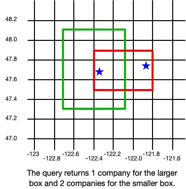
A GeoBox defines a rectangle on the Earth's surface. You define the rectangle by specifying the bottom left (southwest) corner and the top right (northeast) corner.
The following example creates 2 boxes:
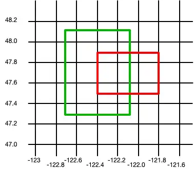
final largeBox = GeoBox( GeoPoint(lon: -122.7, lat: 47.3), GeoPoint(lon: -122.1, lat: 48.1)); final smallBoxSouthWest = GeoPoint(lon: -122.4, lat: 47.5); final smallBoxNorthEast = GeoPoint(lon: -121.8, lat: 47.9); final smallBox = GeoBox(smallBoxSouthWest, smallBoxNorthEast);

Persist Geospatial Data
Important
Cannot Persist Geospatial Data Types
Currently, you can only persist geospatial data. Geospatial data types cannot be persisted directly. For example, you
can't declare a property that is of type GeoBox.
These types can only be used as arguments for geospatial queries.
If you want to persist geospatial data, it must conform to the GeoJSON spec.
Create a GeoJSON-Compatible Class
To create a class that conforms to the GeoJSON spec, you:
Create an embedded object. For more information about embedded objects, refer to Embedded Objects.
At a minimum, add the two fields required by the GeoJSON spec:
A field of type
double[]that maps to a "coordinates" (case sensitive) property in the schema.A field of type
stringthat maps to a "type" property. The value of this field must be "Point".
The following example shows an embedded class named MyGeoPoint that is
used to persist geospatial data:
// To store geospatial data, create an embedded object with this structure. // Name it whatever is most convenient for your application. (ObjectType.embeddedObject) class _MyGeoPoint { // These two properties are required to persist geo data. final String type = 'Point'; final List<double> coordinates = const []; // You can optionally implement convenience methods to simplify // creating and working with geospatial data. double get lon => coordinates[0]; set lon(double value) => coordinates[0] = value; double get lat => coordinates[1]; set lat(double value) => coordinates[1] = value; GeoPoint toGeoPoint() => GeoPoint(lon: lon, lat: lat); }
Use the Embedded Class
You then use the custom MyGeoPoint class in your data model, as shown
in the following example:
// Use the GeoJSON-compatible class as a property in your model. () class _Company { () late ObjectId id; _MyGeoPoint? location; }
You add instances of your class to the database just like any other model.
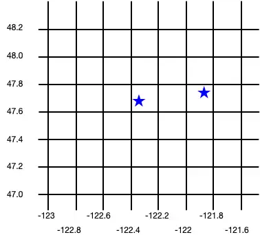
final realm = Realm(Configuration.local([MyGeoPoint.schema, Company.schema])); realm.write(() { realm.addAll([ Company( firstCompanyID, location: MyGeoPoint(coordinates: [-122.35, 47.68]), ), Company( secondCompanyID, location: MyGeoPoint(coordinates: [-121.85, 47.9]), ) ]); });
The following image shows the results of creating these two company objects.

Query Geospatial Data
To query against geospatial data, you can use the geoWithin operator
with RQL. The geoWithin operator takes the "coordinates"
property of an embedded object that defines the point we're querying, and
one of the geospatial shapes to check if that point is contained within
the shape.
Note
The format for querying geospatial data is the same, regardless of the shape of the geodata region.
The following examples show querying against various shapes to return a list of companies within the shape:
GeoCircle
final companiesInSmallCircle = realm.query<Company>("location geoWithin \$0", [smallCircle]); final companiesInLargeCircle = realm.query<Company>("location geoWithin \$0", [largeCircle]);

GeoBox
final companiesInLargeBox = realm.query<Company>("location geoWithin \$0", [largeBox]); final companiesInSmallBox = realm.query<Company>("location geoWithin \$0", [smallBox]);